The Washington Geological Survey releases tsunami evacuation walk time maps for coastal communities alongside video tsunami simulations
OLYMPIA – On the heels of the Great ShakeOut earthquake drill, The Washington Department of Natural Resources (DNR) has released seven new tsunami evacuation maps and several tsunami simulation videos for communities along the state’s northern Pacific coast.
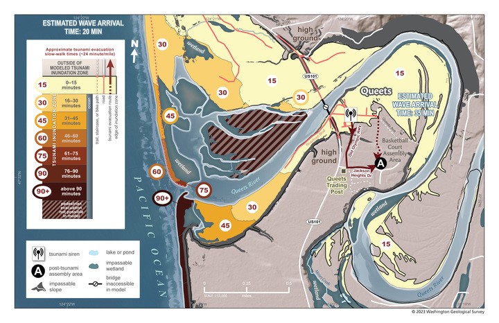
The new maps, produced by DNR's Washington Geological Survey, shows the times it would take to evacuate on foot from the tsunami zones caused by a Cascadia subduction zone earthquake. They show the inundation zone, evacuation routes, and use colors to represent the time it takes to walk to safety from any point within the inundation zone.
“We’ve seen around the world how devastating tsunamis are for coastal communities,” said Commissioner of Public Lands Hilary Franz. “In the event of a tsunami, nothing is more important than knowing where to go to be safe and how long it will take to get there. That is why our geologists are doing the vital work of making this life-saving information easily accessible for everyone who lives, works, or plays along Washington’s coast.”
The new maps cover Ocean City to Copalis Beach, Copalis Beach to Pacific Beach, Moclips, Taholah, Queets, Hoh, and La Push. The study assumed a walking pace is 2.46 miles per hour, however effective walk times vary based on topography.
A tsunami produced by an earthquake along the Cascadia subduction zone can follow an earthquake within a mere 10-15 minutes. That’s why DNR researchers produce these maps – so anyone along the coast can know their route before a tsunami strikes.
The Washington Geological Survey has also released three new sets of simulation videos for the central Washington coast that show the extent and depth of tsunami inundation (on-land flooding) and maximum current velocities following a modeled magnitude 9.0 Cascadia earthquake and tsunami. The videos also provide an estimate for how much time will transpire between the earthquake and the arrival of tsunami waves on shore.
The new simulation videos reveal the dynamics of the tsunami waves by showing how wave heights change throughout the entirety of the tsunami event, a span of many hours.
The simulation videos also show current velocities, which is particularly important for assessing maritime hazards. Partially enclosed bodies of water like bays and harbors can be particularly dangerous during a tsunami due to tumultuous and rapid currents produced during a tsunami.
The simulation videos are viewable on the DNR YouTube channel and downloadable as MP4 files at https://www.dnr.wa.gov/programs-and-services/geology/geologic-hazards/tsunamis#tsunami-simulation-videos
The new pedestrian evacuation maps and maps for other communities are available through an interactive map on the DNR web site: https://www.dnr.wa.gov/programs-and-services/geology/geologic-hazards/tsunamis#preparation-and-evacuation.6
The interactive map also provides access to tsunami evacuation brochures for areas that do not have walk time maps yet. Other information about impacts from earthquakes to Washington communities is available on DNR’s Geologic Information Portal at: https://geologyportal.dnr.wa.gov
323 years since Cascadia last quaked
The geologic record shows the Cascadia subduction zone – the offshore area where the Juan de Fuca tectonic plate is pulled under the larger North American plate – produces megathrust quakes about every 300 to 600 years.
These maps are modeled on a magnitude 9 Cascadia earthquake. The onshore and offshore geologic record shows the last big earthquake happened in 1700 creating a tsunami that hit all the Pacific Northwest and traveled across the ocean to Japan.
By using the models for large Cascadia events, the maps provide a scenario that is useful for smaller events as well.
Geology in the Public Interest
Under the guidance of Commissioner of Public Lands Hilary Franz, the Washington Geological Survey works to ensure the safety and economic well-being of Washington’s citizens from geologic events. The Survey is the primary source of geological products and services for Washington’s government agencies, businesses, and the public.